


FEMA ESTUARY MAPPING
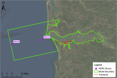
The Federal Emergency Management Agency (FEMA) is in the process of preparing flood maps for the Columbia River Estuary. This process, which began in 2009, is expected to be completed in July/August 2023, when FEMA will issue updated flood risk maps. The study area encompasses an area that begins 20 nautical miles outside the mouth of the Columbia River (NDBC Station 46029) and extends to Cathlamet, WA.
BE FLOOD SAFE!
As we approach our rainy season it's important to be prepared for potential flooding situations.
BEFORE a flood:
- Take photos of structures and belongings for insurance purposes
- Plan for evacuating the area if water rises and have a go-bag packed (don't forget plans for pets and livestock!)
- Track river conditions and sign-up for emergency alerts
DURING a flood: Turn Around - Don't Drown
AFTER a flood:
- Ensure your family is safe and the area has been cleared for you to return
- Contact your insurance agent
- Contact Community Development (503-325-8611) to determine whether your property has sustained Substantial Damage and to determine what permits will be required to complete repairs
Current Conditions, Alerts & Warnings
- Weather, Tsunamis, River Levels, Smoke Advisories, Recent Earthquakes, Tides and Volcanic Activity
- Clatsop Alerts Messages sent to the Public (Emergency Notifications & Community Information)
NATIONAL FLOOD INSURANCE PROGRAM (NFIP)
In order for Clatsop County residents to be eligible for the National Flood Insurance Program (NFIP) the County has agreed to adopt and enforce a floodplain management ordinance (Section 5.1000, LAWDUC) that meets or exceeds the NFIP requirements set by the Federal Emergency Management Agency (FEMA). Clatsop County began participating in the NFIP in 1978.
The areas of special flood hazard are identified in the following FEMA documents:
- The Flood Insurance Study (FIS) #41007CV001B and #41007CV002B, dated June 20, 2018, Version Number 2.3.2.0, for unincorporated areas of Clatsop County
- The Flood Insurance Study (FIS) #41007CV001A and #41007CV002A, dated September 17, 2010, for unincorporated areas of Clatsop County
Links to both studies are provided below.
If you feel the FEMA flood maps do not accurately reflect the flood risk to your property, you may pursue a Letter of Map Amendment from FEMA.
Flood Insurance
It is important to purchase flood insurance prior to a flooding event. It typically takes 30 days for a new flood insurance policy to take effect.
Flood Hazard Zones
The land area covered by the floodwaters of the base flood is the Special Flood Hazard Area (SFHA) in NFIP maps. The SFHA is the area where the NFIP's floodplain management regulations must be enforced and the area where the mandatory purchase of flood insurance applies. All developments in a Special Flood Hazard Area requires a permit from the Land Use Planning office.
What is an SFHA (aka “flood zone”)?
The land area covered by the floodwaters of the base flood is the Special Flood Hazard Area (SFHA) in NFIP maps. The SFHA is the area where the NFIP's floodplain management regulations must be enforced and the area where the mandatory purchase of flood insurance may apply. All development in a Special Flood Hazard Area requires a permit from the Land Use Planning office.
Zone A - Areas subject to inundation by the 1-percent-annual chance flood event generally determined using approximate methodologies. Because detailed hydraulic analyses have not been performed, no Base Flood Elevations (BFEs) or flood depths are shown. Mandatory flood insurance purchase requirements and floodplain management standards apply
Zone AE - Areas subject to inundation by the 1-percent-annual-chance flood event determined by detailed methods. Base Flood Elevations (BFEs) are shown. Mandatory flood insurance purchase requirements and floodplain management standards apply.
Zone AH - Areas subject to inundation by 1-percent-annual-chance shallow flooding (usually areas of ponding) where average depths area between one and three feet. Base Flood Elevations (BFEs) derived from detailed hydraulic analyses are shown in this zone. Mandatory flood insurance purchase requirements and floodplain management standards apply.
Zone AR - Areas subject to inundation by 1-percent-annual-chance shallow flooding (usually sheet flow on sloping terrain) where average depths are between one and three feet. Average flood depths derived from detailed hydraulic analyses are shown in this zone. Mandatory flood insurance purchase requirements and floodplain management standards apply.
Zone V - Areas subject to inundation by 1-percent-annual-chance shallow flooding (usually sheet flow on sloping terrain) where average depths area between one and three feet. Average flood depths derived from detailed hydraulic analyses are shown in this zone. Mandatory flood insurance purchase requirements and floodplain management standards apply.
Zone VE - Areas subject to inundation by 1-percent-annual-chance flood event with additional hazards due to storm-induced velocity wave action. Base Flood Elevations (BFEs) derived from detailed hydraulic analyses are shown. Mandatory flood insurance purchase requirements and floodplain management standards apply.